Scale
Scale describes the relationship between a drawing and reality.
It can, for example, be a building plan or a map of a country. On the map or drawing, the scale will always be indicated, for example:
$$ \large 1 : 100 $$
This means that 1 cm on the drawing corresponds to 100 cm, that is, 1 meter, in reality.
It is always the case that the number on the left represents the drawing, and the number on the right represents reality.
Sometimes the ratio can be reversed, for example:
$$ \large 2 : 1 $$
Here the drawing is twice as large as reality. An enlarged scale can be used when drawing something very small in reality, for example an insect or a microchip.
Example
On a map of Denmark, the scale is:
$$ \large 1 : 500.000 $$
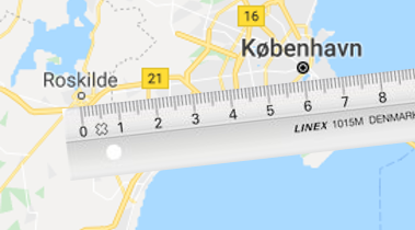
You need to find out how far it is from Roskilde to Copenhagen in reality.
On the map, you measure 6 cm.
Each centimeter corresponds to 500,000 cm in reality. This means you must multiply by 6:
$$ \large 6 \cdot 500.000 = 3.000.000 \text{ cm} $$
So there are 3 million centimeters to Copenhagen. We want to convert that into kilometers.
There are 100,000 centimeters in one kilometer, so you must divide by 100,000:
$$ \large \frac{3.000.000}{100.000} = 30 \text{ km} $$
There are 30 kilometers from Roskilde to Copenhagen.